
NGEE Arctic
Next-Generation Ecosystem Experiments
Advancing the predictive power of Earth system models through understanding
of the structure and function of Arctic terrestrial ecosystems
Landscape Mapping using Remote Sensing and Neural Networks
Landscape Mapping using Remote Sensing and Neural Networks
September 12th, 2018
A convolutional neural network (CNN) approach produced highly accurate vegetation classifications. Hyper-spectral datasets (e.g., AVIRIS) were most useful for our machine learning approaches. Accurate and high-resolution datasets generated using our approach are needed for Arctic models.
The Objective:
- Develop high-resolution maps of Arctic vegetation using machine learning and satellite imagery (e.g., NASA).
New Science:
- A convolutional neural network (CNN) approach produced highly accurate vegetation classifications. Hyper-spectral datasets (e.g., AVIRIS) were most useful for our machine learning approaches. Accurate and high-resolution datasets generated using our approach are needed for Arctic models.
The Impact:
- Remote sensing products were combined and maps of vegetation distribution evaluated against field data for the Seward Peninsula
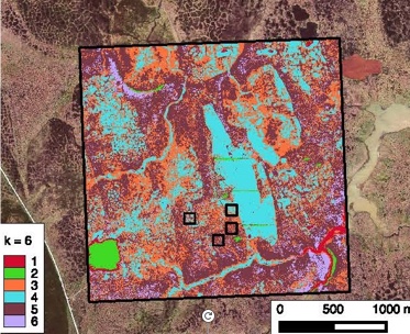
A clustering-based stratification method previously used to map vegetation at NGEE Arctic field sites near Utqiaġvik, AK.