
NGEE Arctic
Next-Generation Ecosystem Experiments
Advancing the predictive power of Earth system models through understanding
of the structure and function of Arctic terrestrial ecosystems
Integration of Unmanned Aerial System, Surface Geophysics & other Multi-Scale Data to Map Arctic Snow Depth
Integration of Unmanned Aerial System, Surface Geophysics & other Multi-Scale Data to Map Arctic Snow Depth
April 3rd, 2017
The ability to map snow depth in high resolution and over a large areas permits for the first time a dataset that can be used to quantify the impact of heterogeneous snow distribution on hydrology and carbon exchange.
The Objective:
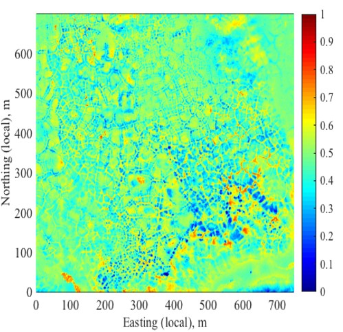
This paper aims to develop an effective strategy to characterize heterogeneous snow depth over the Arctic tundra, using state-of-art techniques (ground-penetrating radar and UAS phodar) and also to quantify the relationship between snow depth and topography. All the techniques provided fairly accurate estimates of snow depth, while they have different characteristics in term of acquisition time and accuracy. We then investigated the spatial variability of snow depth and its correlation to micro- and macrotopography using the wavelet approach. We found that the end-of-winter snow depth was highly variable over several-meter distances, affected primarily by microtopography. In addition, we developed and implemented a Bayesian approach to integrate multi-scale measurements for estimating snow depth over the landscape.
New Science:
We developed a Bayesian approach to integrate a variety of state-of-art snow sensing techniques – in situ measurements, ground-penetrating radar, phodar on unmanned aerial system (UAS) and airborne lidar – for mapping highly heterogeneous snow depth over ice-wedge polygonal tundra. Our analysis also showed that the end-of-winter snow depth was highly variable in several-meter distances, influenced by microtopography.
The Impact:
Snow plays a critical role in Arctic ecosystem functioning, as it influences permafrost thaw, water delivery and carbon exchange. Snow depth is, however, extremely heterogeneous, and traditionally difficult to map in sufficient resolution using conventional point measurements. Although there have been significant technical advances in measuring snow depth (e.g., geophysics and remote sensing), it is still challenging to integrate all these state-of-art data in a harmonized manner due to their different scales and accuracy. The developed Bayesian approach will be an integrating framework for these advanced datasets, allowing us to mesure snow depth at high resolution over a large area.
The estimated mean snow depth across the site (in meters) based on the proposed Bayesian method including the correlation to microtopography.