
NGEE Arctic
Next-Generation Ecosystem Experiments
Advancing the predictive power of Earth system models through understanding
of the structure and function of Arctic terrestrial ecosystems
Understanding Vertical and Horizontal Flow in Ice-Wedge Polygons
Understanding Vertical and Horizontal Flow in Ice-Wedge Polygons
March 31st, 2020
Novel bromide tracer experiments are used to develop a model of subsurface flow and transport within ice-wedge polygons.
The Objective:
- This work, led by Nathan Wales (LANL) sought to better understand the relative roles of vertical and horizontal water fluxes in the subsurface of polygonal landscapes, providing new insights and data to test and calibrate hydrological models.
- Field-scale investigations were conducted at an intensively instrumented location on the Barrow Environmental Observatory (BEO) near Utqiaġvik, AK.
- Using bromide as a hydrologic tracer, Wales and his colleagues investigated a low-centered and a high-centered polygon.
New Science:
- Ice-wedge polygons occupy large areas of the Arctic coastal plain.
- The future of these landforms in a warming climate depends on the bidirectional feedback between the rate of ice-wedge degradation and changes in hydrological characteristics.
- The low-centered polygon exhibited higher flow velocities and more fast flow paths than the high-centered polygon, where limited breakthrough occurred.
- Subsurface lateral flow is strongly influenced by frost table topography.
- Substantial differences in tracer behavior between the low- and high-centered polygons are represented in a newly developed conceptual model of active layer flow paths.
The Impact:
- Apparent horizontal hydraulic conductivities were found to be of the same magnitude as vertical conductivities for fast flow paths, highlighting that flow is not consistent with the 1-D downward flow assumption used in some polygon modeling approaches.
- The overall tracer mass recoveries were low, suggesting that tracer transport through bulk soil was much more limited than in the preferential flow paths.
- Data collected just before freeze-up and just after thaw suggests that transport over the winter period was important, resulting in significant changes in tracer concentrations at multiple locations.
- These results will prove useful in developing the next generation of hydrology models for tundra landscapes.
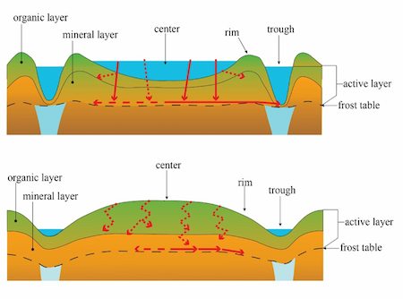
Conceptual diagram of flow paths in low-centered and high-centered ice-wedge polygons. Red arrows indicate transport pathways. Length of arrow indicates relative flux. Dashed arrows indicate lower fluxes than solid arrows.