
NGEE Arctic
Next-Generation Ecosystem Experiments
Advancing the predictive power of Earth system models through understanding
of the structure and function of Arctic terrestrial ecosystems
New Model Predicts Soil Drainage
New Model Predicts Soil Drainage
October 21st, 2021
An analytical model predicts how ice-wedge polygon geometry influences the export of solute-rich waters from tundra soils to ponds and streams.
The Objective:
An analytical model to predict how ice-wedge polygon geometry influences the export of solute-rich waters from tundra soils to ponds and streams.
New Science:
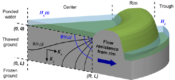
Ice-wedge polygons segment the soil of tundra landscapes into distinctive units resembling the cells of a honeycomb, but measuring up to thirty meters across. Individual polygons are often bounded by rims of soil up to a half meter high and function as miniature basins, storing surface water in the central depression. This unique geomorphology results in complex drainage processes, whereby the water in the central depression slowly flushes outward through the soil of the rims over the course of the summer, discharging into a network of troughs at the polygon boundaries. This flushing has the potential to mobilize large amounts of soil organic carbon and dissolved nutrients as climate change causes polygonal troughs to deepen and the discharge of water to intensify. A new physically-based, analytical model simulates this complex hydrology in three dimensions, predicting how quickly the ponds in the centers of polygons drain and what fraction of the subsurface is flushed by this drainage. The model reveals that drainage is strongly influenced by geometric attributes which can be measured from space. Ice-wedge polygons with small diameters, for example, drain more quickly and are more thoroughly flushed than others. The model also reveals that as climate change deepens the active layer in ice-wedge polygons, the fraction of the subsurface which is flushed grows, increasing the potential for export of soil organic carbon and other nutrients into surface water. Because the model uses an analytical approach to simulate groundwater flow, it runs very fast and thus is an ideal tool to efficiently identify the mechanisms and processes acting to move water across these unique landscapes.Insights from the model will eventually be used to improve representation of the complex near-surface hydrology of polygonal tundra landscapes in coarser-resolution Earth System Models, such as DOE’s E3SM.
The Impact:
Insights from the model will eventually be used to improve representation of the complex near-surface hydrology of polygonal tundra landscapes in coarser-resolution Earth System Models, such as DOE’s E3SM.
A schematic of the model, which uses fundamental hydrologic principles to simulate the flushing of water from the central depression of an ice wedge polygon outward toward the trough.